
you know me- always organized & prepared. But jeez, the PCT? This has been a puzzle to figure out (especially on the highest snow year of all time). In between work full-time, building out my trailer, and the normal chaos of life… it’s been hard to adequately prepare.
it’s been a lot of (before work) map comparing, guidebook reading, and PCT Facebook group scrolling.
since a lot of y’all are asking what my level of preparation is, I’ll break it down for you into a few sections.
Routes & Camp
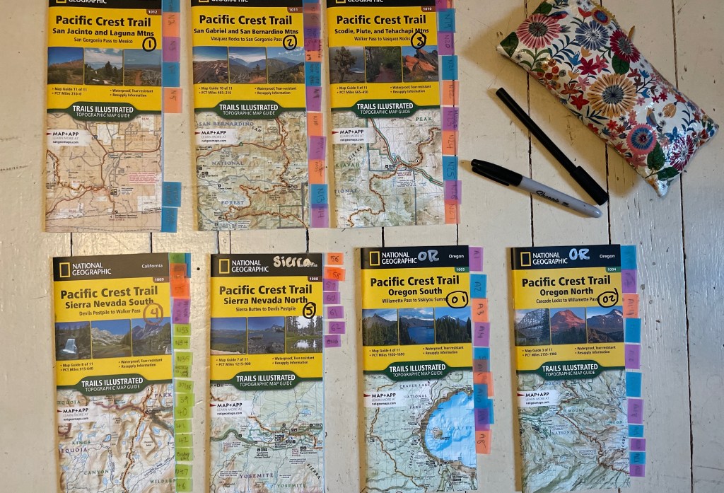
so, I started out by reading the “Mountaineers Books Hiking the Pacific Crest Trail” for each section, (while working at Red Cross blood drives) this Summer & Fall. Any spare moment I could get between climbing trips, building my home, & work… I was deep diving into the best daily routes.
There are many many ways to hike the PCT, hundreds of campsites, and it is totally possible that my daily “camps” won’t be where I actually camp. BUT- I have a plan and if all else fails at least I am well prepared. By marking my camps, I have a good goal to aim for each day and can just focus on that (without having to calculate how long my food & water will have to last).
& for each day, I have broken it down into: camp start, camp start, elevation change, mileage to camp, overall mileage, every water source, and general notes on each section. Some sections have creeks every mile, while some water carry’s are 15+ miles. I’ve been a bit spoiled with all the water we have in the idaho backcountry!
these Google Sheets are on “offline mode” on my phone, and (laminated) in my backpack.
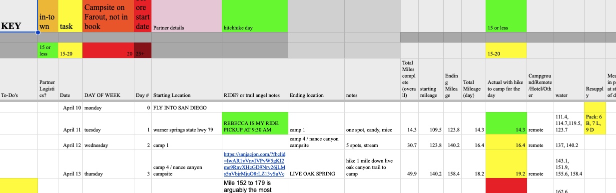
for my maps, I have each paper map charted with every single camp location and each of those is also marked (with the same “camp name”) on my Far Out map app on my phone…AND this is all referenced on my excel sheet, so my family at home can look up my expected location on Far Out’s desktop website & compare it to the “check-in” location I send via satellite.
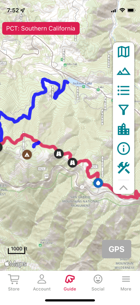
I also have the PCT gpx files onto my Garmin Inreach, Garmin Instinct watch, and Garmin Explore App as well. These are all backups to my FarOut app & paper map.
Alternative Route
& as you know the Sierra is experiencing record breaking snow this year. Like 250% + of normal. So with that in mind, I have a backup route.
Alternative Plan: Instead of hiking Warner Springs to Sonora Pass.. I have a plan to exit at Kennedy Meadows South, rent a car, and drive to Ashland, Oregon. I would resume my hike there after a couple days of recovery. The plan would be to hike from there to Ollalie Lake, just north of Bend! I’m hoping this section is passable. If not, I may consider heading home for a bit and then trying for the Oregon section again.
With the Sierra being crazy snowy, the melt will also be insane. When I get to Kennedy Meadows South (mid May), I will consider all trail reports from individuals already hiking it. If there are enough thaw/freeze cycles and less storms… it may be passable. Many people have said “20 feet?! You’ll sink” but actually, 20 feet, 4 feet, or 10 feet really doesn’t matter as much as how thick the “crust” layer on top is. If the crust is frozen and can support your weight, you’ll stay on top & if you do “post hole” you’ll just go down to your hips (not 20’ down!). While there are chances of late snowfall, it is quite unlikely the snow will be feet upon feet of fluffy powder.
Of course, I am well aware of the dangers of the snow conditions, and avalanches. That is a different story! But just to be clear, in Idaho it is fairly normal to hike in the snow (in even July/ August) at high elevation. In the early AM it’s still frozen (and easy to stay on top of) & after it warms up its a slushy mess. Same goes for the Sierra! Anyhow- I’d much rather deal with 4am hiking on top of snow then raging rivers of snow melt! BUT… we will see when I get to Kennedy Meadows.
& of course there is always the possibility sections of Oregon may also be very snowy. Just going with the flow & believing it will all work out.
Hope that helps clear some snow- related questions up!

& of course IF that is what happens, I want to be able to just get on trail- so each day’s camp, elevation, and mileage is already accounted for. I have my “Oregon” resupply box on standby.
Permits
The PCTA makes the permits a breeze… as long as you can get one! I had to do the following to obtain the permit:
1. Register through the PCTA website, do some short slideshows, and obtain a California campfire permit
2. Sign up to receive a permit slot
3. Got my randomly drawn permit slot time the day before the permitting
4. Logged in (during my short slot time) and picked my start day and entrance point
5. Waited about 10 days to receive confirmation that my permit was approved
6. printed and signed my permit 3 weeks before my start date
& for those asking why I can’t change it to a later date… well if I tried to do that, I’d have to firstly give up my permit and then look at the PCTA calendar and see if there were any open slots. I’m order to be confirmed, I would have to give up my current time first.
& As for “skipping” ahead to Ashland, my permit is for northbound travel. So as long as I stay northbound, and don’t switch to southbound the PCTA will have no issue with me jumping ahead closer to the northern terminus.
Resupply
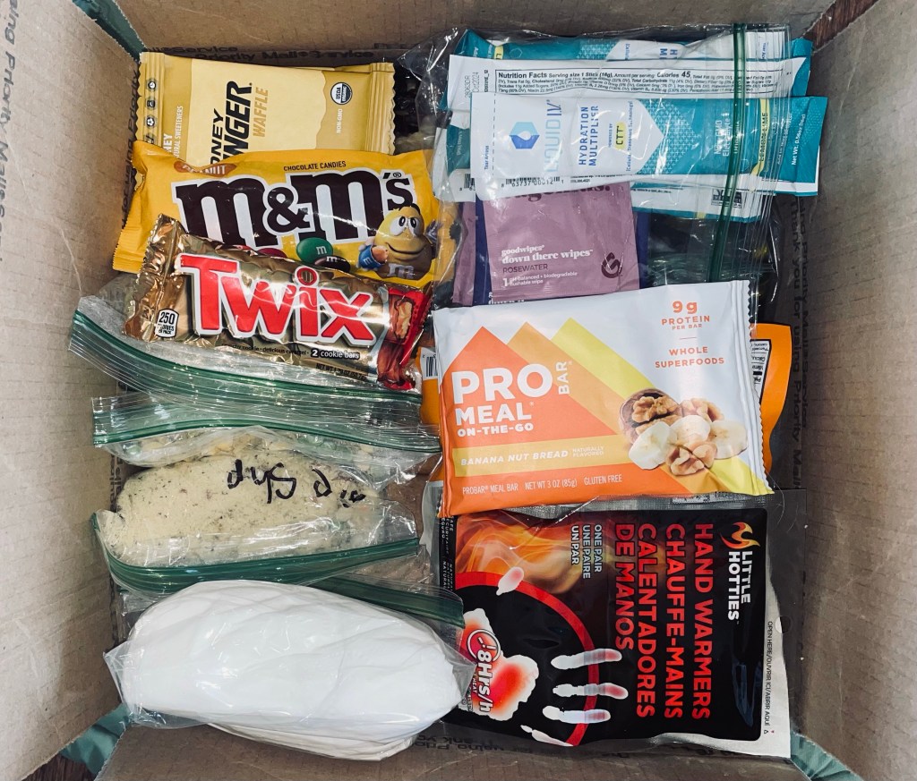
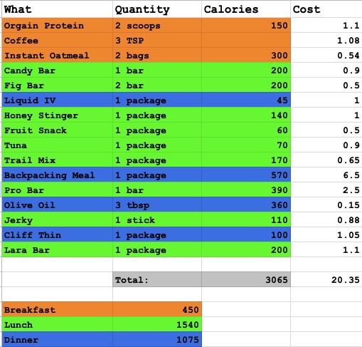
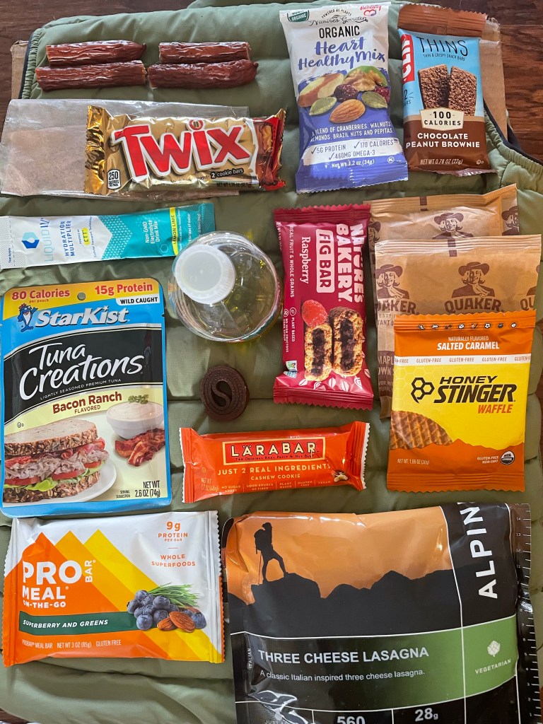
Resupply, oh the chaos! Many hikers just resupply on trail (which is great if you can afford it!) to support the local towns. I got bulk backpacking meals through my ExpertVoice ProDeal, & bulk snacks off of Amazon & Target.com. Below is my daily intake- just over 3,000 calories.
Just about every 10 days, I have a delivery planned. All of the addresses, pick up times, fees, and contents for each box are accounted for on my Google Sheet. The boxes are all taped & the address labels are printed & ready (not taped on…Just in case of last minute changes). Through Priority mail, all my mom has to do is set a pickup date online & BAM they will pick it up, and then ship it to me for a standard rate.

Physical Prep
At the gym, I hit the row machine & stair stepper 2x per week since September. Each week I trail run at least once, and try to go on a hike at least twice. Lately, I’ve been hiking and/ or walking at least 5 miles a day. I have been taking my 45lb pack on all of my hikes & walks, and the hip bruises have already developed.
For those who have been on hikes with me, you know my pace is a 15 minute mile. If my knees and back can hold up, I would expect to keep my pace throughout the entire 1,000 miles (if not get faster).
Unpacking & Repacking

With so much time in between “planning to hike” and “holy cow, I’m going to be hiking for 2 months,” I have re-packed about 15 times. Things I have added: Crocs, Sleeping Bag Liner, Duck tape, Compass, Nalgene, Knee Braces, Wag Bags. Things I have removed (but MAY add back in later): Sunhat, Tablet, Thick socks (not compatible with my shoes). My “fix it” kit & “med” kit are complete & everything is organized into cute little dry-bags from Walmart. My pack is heavy, but evenly balanced, and everything is easily accessible.

Leave a comment